The bayesEO package provides a Bayesian approach to post-processing ML-generated images. It refines class probabilities, removes outliers, and improves labeling for more accurate classification.

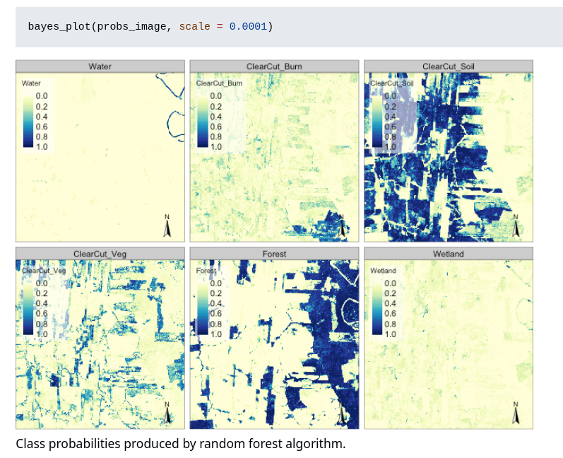
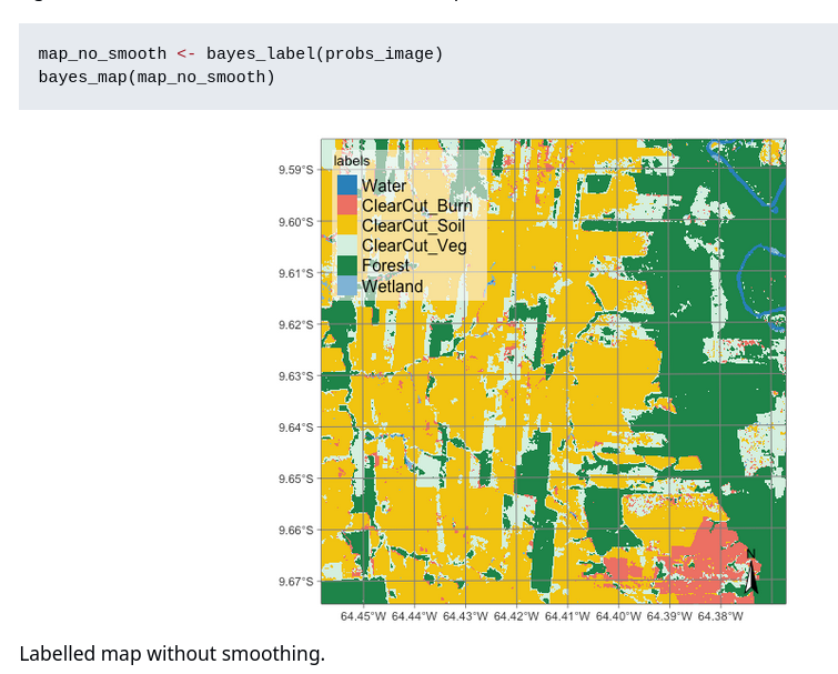
The bayesEO package provides a Bayesian approach to post-processing ML-generated images. It refines class probabilities, removes outliers, and improves labeling for more accurate classification.
WIP pkgdown site now up for {vrtility} https://permian-global-research.github.io/vrtility/
Managed to iron out a good few bugs and a bit more parallel stuff so it's starting to come together 
#rstats #rspatial #gdal

 Our poster, "An Inventory of Spatial Machine Learning Packages in R" was presented at #FOSSGIS2025 in Münster.
It compares caret, mlr3, and tidymodels for spatial ML and highlights other relevant R packages.
Poster and related materials, including code: https://loek-rs.github.io/FOSSGIS2025-examples/
#rstats #rspatial #machinelearning @FOSSGISeV

Anyone know if there are WorldClim mirrors around with COG (geotiff) or Zarr cloud ready support. The main repo is glacial.
Managed to give my {vrtility}  #rstats #rspatial package a huge boost - I've ditched rioxarray/dask and now use {mirai} (via {purrr}) and {gdalraster} for asynch download/processing
 . https://github.com/Permian-Global-Research/vrtility

FOSSGIS 2025 is coming to Münster this week! Looking forward to meeting fellow FOSS4G enthusiasts.
We’ll be presenting a poster on spatial machine learning in R. Stop by and let’s chat!

If you are a regular user of #Rstats for geospatial work, would you say that the #RSpatial ecosystem is, broadly-speaking, in a good place following the recent retirements of GDAL etc?
Specifically, I am interested in whether you think the #RSpatial workflow is user-friendly and efficient.
Edit:
I am referring to the rgdal and rgeos package retirements.
**geometa** provides an essential object-oriented data model in R, enabling users to efficiently manage geographic metadata.
The package facilitates handling of ISO and OGC standard geographic metadata and their dissemination on the web.
In this interview, we speak with **Emmanuel Blondel**, the author of geometa, ows4R, geosapi, geonapi and geoflow—key R packages for geospatial data management.
https://r-consortium.org/posts/exploring-geometa-an-r-package-for-managing-geographic-metadata/

Introducing {maposm}, an R package that extracts, modifies and merges sets of layers from OpenStreetMap for cartographic purposes.
On github: https://github.com/riatelab/maposm
The package is not on CRAN, but it is on r-universe: https://riatelab.r-universe.dev/maposm


Distanamo is an R package by Matthieu Viry for creating distance cartograms (distance anamorphoses). It helps visualize spatial distortions based on distance constraints.
Learn more: https://buff.ly/v7gxXNq

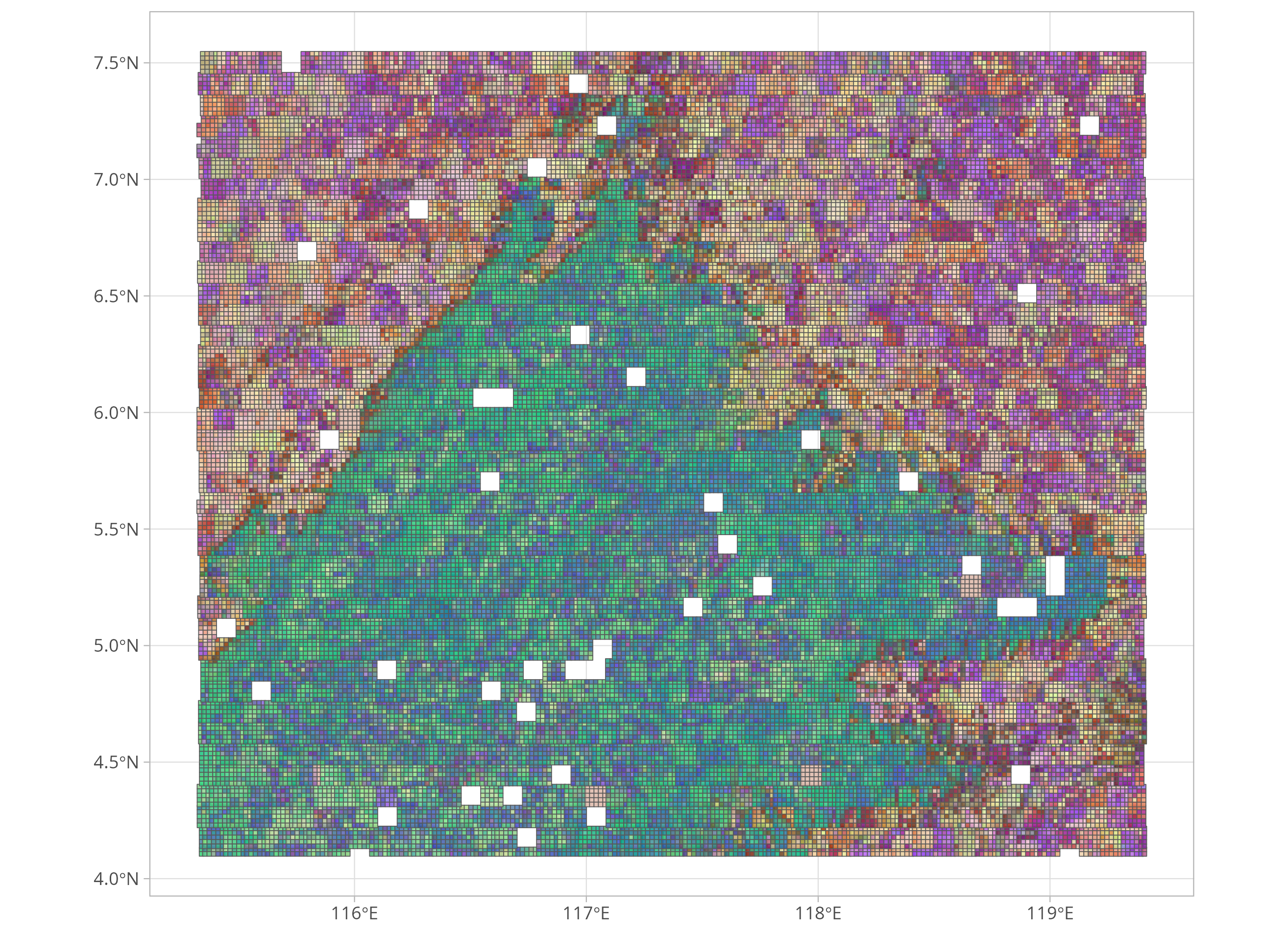
If, like me, you want to figure out wtf geospatial embeddings are, then grab some from major-tom and be as confused as me!
here's an #rstats #rspatial function to grab the data with duckdb:
https://gist.github.com/h-a-graham/53a7ce9a3095245017acf93f6c674754
Explore the blog series on comparing spatial patterns in raster data using R. 

- Techniques for analyzing continuous and categorical data
- Handling overlapping and arbitrary regions
- Advanced methods for comparing spatial patterns
Find the full series at https://buff.ly/s35030O


This {vrtility} project is still a WIP but I think the potential and flexibility of the approach is huge - basically just let #gdal do all the work. I've finally got my head around how the sequence of things should fit together but it is still missing a few important features. If you're interested in #rspatial #remotesensing I'd love your thoughts and feedback. powered by #gdalraster
https://github.com/Permian-Global-Research/vrtility/tree/better-readme
40 free tip sheets, presentations, and/or repos from awesome data journalists, professors & researchers, from last week's #NICAR25 conference.
Learn about mapping/GIS, GitHub Actions, R, Python, LLMs, command-line tools, JavaScript, and lots more.
Links at https://www.machlis.com/nicar/
 – Matt Waite, MaryJo Webster, Derek Willis
Climate change has changed natural disasters; Naturally, we must change how we prepare and inform – Adiel Kaplan, Teghan Simonton, M.K. Wildeman, Christopher Keller
Custom Dataviz with JavaScript – Jovi Dai, Yoli Martinez, Matt Kiefer
Customizing ggplot for yourself or your organization – Athena Chapekis, Kaitlyn Radde (Pew Research Center)
Cutting-Edge Web Scraping Techniques – Simon Willison
De-mystifying cryptocurrency data – Caitlin Ostroff, Jeremy Merrill
Don't Repeat Yourself in R – Ella Barnes, Karina Kumar
Education Data Sources – Sharon Lurye
Election Data to Use After the Election – Derek Willis
The table also shows tags, type of resource, and year")
I'm super happy to see that several of my data visualisation projects were long-listed at the 2024 Information is Beautiful Awards!
Check out the full longlist here: https://www.informationisbeautifulawards.com/showcase?action=index&award=2024&controller=showcase&page=1&pcategory=long-list&type=awards


Process spatial data and create reproducible maps with R using "Cartography with R" by Timothée Giraud. Covers R Spatial, data manipulation, thematic maps, and more.
Read it at: https://buff.ly/sIqGXss

Fun with shapes: Scripted mapping in R or Python
"Let's face it, QGIS is the Excel of geospatial analysis. Sure, doing simple mapping in it and ArcGis is a blast, but executing complex, reproducible joins and measurements can be a real drag. Whether you choose R or Python, follow along from mapping basics to more complex techniques that will make your next geospatial analysis a walk in the park." By Alexandra Kanik
https://github.com/akanik/nicar25-scripted-mapping/blob/main/scripted-mapping.md
#RStats #Python #GIS #RSpatial #Maps

Kyle Walker's 3rd free workshop on mapping US Census data with R is now on YouTube! Hour 2 is on using his new {mapgl} #RStats , followed by some advanced workflows in hour 3. I attended live and got a lot of it, highly recommend.
https://www.youtube.com/watch?v=4WZfw0K7Vx8
#RSpatial #GIS