Reading Material With Lunch, Etc – Getting Back To My Roots
--
https://doi.org/10.4324/9780429270284 | Thornes, J. B., Brunsden, D. (1977). Geomorphology and time. London: Methuen
--
I saw this book on another post - and so went and found a copy at a 2nd hand book shop…
Looking forward to lunches at work with a cup of tea and maybe a couple of rainy Sundays at home…
--
#geomorphology #text #book #landforms #learning #refamiliarisation #readingforpleasure #framework #model #processes #geology #water #hydrology #weather #climate #erosion #time #spatialanalysis #spatiotemporal #temporal #qualitative #quantitative #change #stochastic #evolution
Recent searches
Search options
#erosion
Thawing Permafrost Primes Slumps
As permafrost thaws on Arctic hillsides and shorelines, the land often deforms in a unique fashion, known as a slump. Formally known as mega retrogressive thaw slumps, these areas superficially resemble a landslide. They’re also prone to repeat performances: as many as 90% of Canada’s Arctic slumps recur in the same place as previous slumps. Researchers used ground-penetrating radar and other tools to study the underground structure at slumps and found that several factors contribute to this repetitive cycle.
Seawater soaking into the foot of a hilly shore can destabilize the permafrost, creating a slump. That changes the nearby ground cover, exposing more permafrost to warming; their measurements showed this warming could extend tens of meters underground, priming the area for future slumps. Similarly, the mudslides and narrow ravines that form on an active slump also shift away ground cover and warm the underlying permafrost. Together, these factors suggest that once a slump forms, more slumps will occur as the underlying permafrost warms. (Image credit: M. Krautblatter; research credit: M. Krautblatter et al.; via Eos)
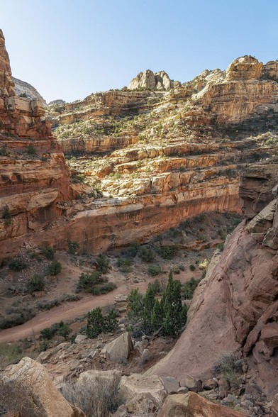
The view of rocky cliffs and a meandering trail below, viewed along the Cassidy Arch hiking trail in Capitol Reef National Park, Utah.
#capitol reef #nationalpark #landscape #landscapephotography #cassidyarch #utah #rocky #erosion #cliffs #rockformations #BuyIntoArt #AYearForArt #artforsale #wallartforsale #giftideas @joancarroll
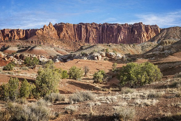
I loved this scenic view in Capitol Reef National Park because of all the layers of flora and rock formations from a foreground of shrubs and grasses to distant background red rock cliffs. The scene shows the rugged beauty of the desert environment.
#capitolreef #nationalpark #landscape #landscapephotography #utah #rocks #rocky #erosion #geology #artistic #shrubs #grasses #BuyIntoArt #AYearForArt #artforsale #wallartforsale #giftideas @joancarroll
https://joan-carroll.pixels.com/featured/capitol-reef-national-park-utah-landscape-joan-carroll.html
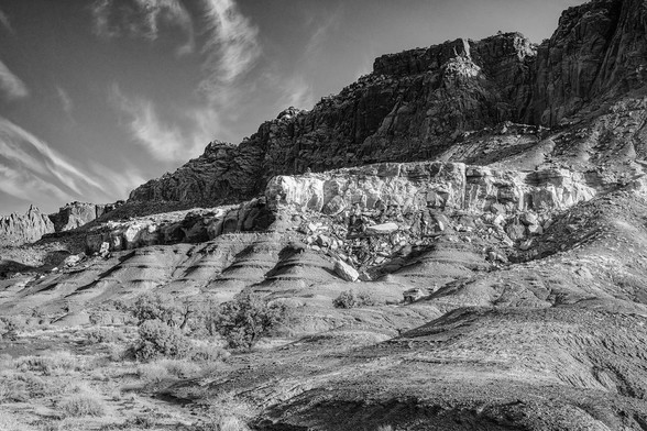
Rugged cliffs in Capitol Reef National Park rise dramatically to contrast with the sky’s delicate wispy clouds. Early morning light highlights the multiple layers of sedimentary rock that record 200 million years of geologic history. Processed in black and white.
capitolreef #nationalpark #blackandwhite #blackandwhitephotography #landscape #landscapephotography #geology #erosion #utah #rocky #BuyIntoArt #AYearForArt #artforsale #wallartforsale #giftideas @joancarroll
https://joan-carroll.pixels.com/featured/capitol-reef-national-park-landscape-2-bw-joan-carroll.html
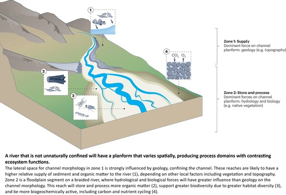
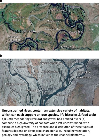
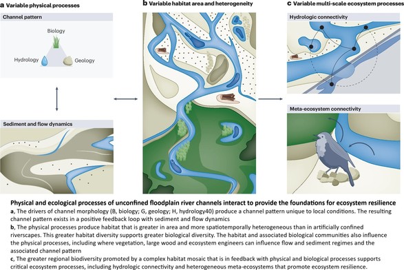
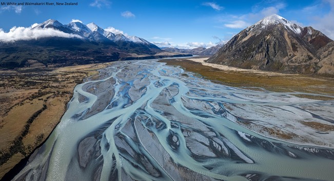
The Ecological Benefits Of More Room For Rivers
--
https://doi.org/10.1038/s44221-025-00403-0 <-- shared technical article
--
#spatial #spatiotemporal #morphology #meander #levee #understanding #oxbow #pointbar #river #water #hydrology #landform #geomorphology #geomorphometry #geology #fluvial #riverine #weather #climate #erosion #sediment #sedimentation #DEM #floodplain #terraces #ecsosystems #ecology #sustainable #climatechange #flood #floodrisk #risk #hazard #management #planning #monitoring #migration #engineering #unconfined #rive #channel #metaecosystem #connections #biodiversity #extremeweather
Fluvial System Block Diagrams
--
I was looking to understand a fluvial system the other day, up in the high Arctic, as I looked at 3DEP remote sensed elevation data… I have always been fascinated by the how geology, water, weather shapes a landscape, including erosion (aka geomorphology if you will) – and realized how very much value fluvial block diagrams have as we try to conceptualise what has, is and will happen(ed.)
#spatial #spatiotemporal #morphology #meander #levee #understanding #oxbow #pointbar #river #water #hydrology #landform #geomorphology #geomorphometry #geology #fluvial #riverine #weather #climate #erosion #sediment #sedimentation #Arctic #3dep #opendata #DEM #BeringSea #northslope #opendata #fedservice
#landscape #landscapephotography #fineartphotography #geology #alienlandscape #striated #erosion #badlands #southdakota #midwest #nationalpark #mesa #fujifilm #fujixseries
82/365
Contractors need to be held accountable for mindless cutting of trees.
Contact SKANSKA and tell them that you are outraged that they cut a grove trees without permission, causing erosion and flooding.
Contractors need to be held accountable and heavily fined.
Boston, MA
+1 617 574 1400
101 Seaport Blvd
Boston, Massachusetts 02210
You can also contact RIDOT to see if they will fine them Phone: (401) 222-2450

Lifeless rock pools at Sawtell
After cyclone Alfred whipped up a 'bacteria smoothy' along Australia's east coast the sea foam then merged with a 'flush' from the suburbs. Dislodged smelly sponges at Sawtell beach made breathing and contact impossible. Even without fossil fueled disasters the intertidal zone at the north end of the beach is barren. The rock pools and crevices no longer house sea anemones, crabs, black nerites, limpets, sea stars, mulberry oyster borers, algae, sea anemones, sponges, tube worms, sea stars, oysters, and fish.
Still good enough for hosting 'sports' and advertising events amplified by megaphone so they can be heard at Lord Howe Island too.
Details of curving rock formations display intricate patterns and rich hues along the edge of Lago Argentino in the Patagonia region of Argentina. Sparse greenery is along the top, contrasting with the textured surface below. Processed with painterly finish.
#rocks #rocky #rockformations #curving #argentina #patagonia #artistic #geology #landscape #landscapephotography #patterns #terrain #erosion #AYearForArt #buyIntoArt #giftideas #wallart #artforsale @joancarroll
https://joan-carroll.pixels.com/featured/rock-formations-lago-argentino-patagonia-joan-carroll.html
#Geograph #photo no. 8,000,000 ! A classic example of change recorded by JThomas at #Sewerby, #EastRiding #Yorkshire #clifffall #chalk #erosion #change
#photography #coast
https://geograph.org.uk/p/8000000
Free to share – please credit JThomas/Geograph
The home page says "Since 2005, 13,980 contributors have submitted 7,964,955 images covering 282,951 grid squares, or 85.2% of the total squares"
The reason for the numeric discrepancy is that not all submissions pass moderation
“When the environment improved, all the birds returned."
Unsustainable grazing and land abuse can be reversed
>>
https://www.theguardian.com/environment/2025/mar/14/how-china-led-way-water-soil-conservation
#livestock #degradation #agriculture #farming #erosion #dust #conservation #Australia
Cyclone Alfred (2025) Erosion
https://www.abc.net.au/news/2025-03-15/drone-maps-reveal-scale-of-sand-swallowed-in-cyclone/105053372
Bribie Island (2025) “new passage”
https://www.abc.net.au/news/2025-03-14/call-for-action-on-bribie-island-erosion-after-cyclone-alfred/105045738
There is a stream down the hill from my house. It winds down a a valley to the larger stream I mentioned yesterday
The valley has been used by folks for a couple of hundred years, there is a main road that crosses the stream several times and many houses built right up to the banks.
Undercutting has been a problem due to the apparent increase in storm intensity over the last decade or so.
Erosion is a constant and various means have been attempted to keep it under control. Down the street from me is a concrete lined section.
This particular job is a continuation of a more recent attempt using more “natural” methods to keep things in check.
The stream has been carrying a pretty heavy silt load for the last couple of months. It had previously run pretty clear.
This is some of the current silt control. The pipe is carrying the stream from the other side of the construction area. Does not seem to be working all that well.
It could be worse.
#AsSeenWalking #MyPhoto #natureish #erosion
Strandbeest Evolution
Theo Jansen’s Strandbeests are massive, wind-powered kinetic sculptures designed to roam Dutch beaches. Conceived in the late 1980s as a way to kick up sand that would replenish nearby dunes, the beests have grown into a decades-long obsession for the artist and his followers. This Veritasium video charts the development and evolution of the Strandbeest from its original concept through Jansen’s increasingly self-sufficient versions. I found the leg linkage of the Strandbeest especially fascinating. How neat to find a relatively simply proportion of linkages capable of turning a small crank’s motion into a stable walking gait. Anyone else feel like building a miniature Strandbeest now? (Video and image credit: Veritasium)
Icelandic Flows
Known as “The Land of Fire and Ice,” Iceland has some of the most striking landscapes around. Photographer Jennifer Esseiva captures auroras, waterfalls, geysers, rivers, and more in this series from her 2024 trip to the island. Every one of these images bears the fingerprints of fluid dynamics: plasma flows lighting up the night sky; rivers of lava that formed the land; rivers and oceans that carve through the landscape; and pressurized, superheated water that shoots up from underground plumbing. (Image credit: J. Esseiva; via Colossal)
Flooding the Mediterranean
Nearly 6 million years ago, the Mediterranean was cut off from the ocean and evaporated faster than rivers could replenish it. This created a salty desert that persisted until about 5.3 million years ago. One hypothesis — the Zanclean megaflood — suggests that the Mediterranean refilled rapidly through an erosion channel near the Strait of Gilbraltar. A new study bolsters the concept by identifying geological features near Sicily consistent with the megaflood.
The team point to a grouping of over 300 ridges near the Sicily Sill, once a land bridge dividing the eastern and western Mediterranean and now underwater. The ridges are layered in debris but aren’t streamlined, suggesting they were rapidly deposited by turbulent waters, and date to the period of the proposed flooding. For more on the Zanclean Flood, check out this older post. (Image credit: R. Klavins; research credit: A. Micallif et al.; via Gizmodo)
A Eucalyptus cautionary tale from Nepal.
They could also have chosen Portugal, where Eucalyptus plantations cause wildfires.
https://news.mongabay.com/2025/02/in-nepal-a-eucalyptus-boom-became-an-ecological-cautionary-tale/


