dmv.community is one of the many independent Mastodon servers you can use to participate in the fediverse.
A small regional Mastodon instance for those in the DC, Maryland, and Virginia areas. Local news, commentary, and conversation.

Administered by:

Server stats:

170
active users

#ncwx

47 posts14 participants0 posts today

#NCwx

Area Forecast Discussion
NWS Raleigh NC
454 AM EDT Fri Apr 4 2025

NEAR TERM

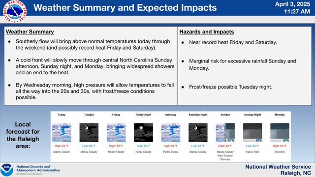
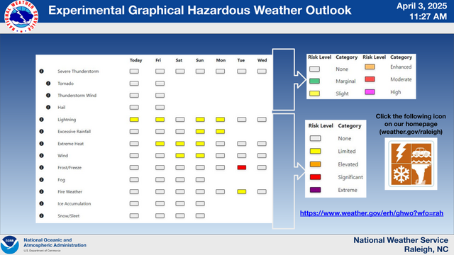
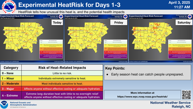
The stationary front extending from the DELMARVA region and across the TN Valley into the deep south will waver today. While the morning will be cloudy across much of Central NC clouds are expected to scatter out in the afternoon. Afternoon daytime heating will increase temperatures quickly with highs expected to be in the mid to upper 80s, however a few spots could reach 90 degrees. If clouds stick around later into the afternoon expect temps to be a few degrees lower than current forecast. With record high temps possible today, KGSO(87) and KRDU(90), heat related impacts are in a Moderate Category which will affect individuals sensitive to heat, especially those without effective cooling and/or adequate hydration. In the afternoon the northern section of the front extending from TN to NJ will slowly sag south along the VA/NC border bringing isolated showers in the evening hours. The front will then stall near the NC/VA border leaving lows in the mid 60s north to upper 60s south.

Replied in thread

@easwatch #NCwx #NorthCarolina #EAS #WEA for NC North Carolina Department of Public Safety: Endangered Missing Child - DURHAM, NC: Icelyn Wilson, 2 year old black male. Maybe in a White 2019 Nissan Rogue, VX51815. Last known to be on Berwyn Ave or Alston Ave. If seen, call 911. Source: 200071,NC North Carolina Department of Public Safety,North Carolina Center for Missing Persons ** DO NOT RELY ON THIS FEED FOR LIFE SAFETY, SEEK OUT OFFICIAL SOURCES ***

#NCwx

Area Forecast Discussion
NWS Raleigh NC
500 AM EDT Thu Apr 3 2025

NEAR TERM

…unseasonably strong and warm, sub-tropical high pressure that will extend from near and south of Bermuda wwd and throughout much of the Southeast, including all of cntl NC. A separate differential heating boundary/zone will also likely develop and retreat across cntl NC today, with a southeast to northwest erosion of the now widespread, mostly MVFR stratus, and with associated cloudy or mostly so conditions that will linger longest and into early to mid-afternoon over the nw Piedmont.

Temperatures throughout cntl NC will warm mostly into the 80s and well above average (~ +15F), except upr 70s possible where the aforementioned low clouds take longest to erode. After patchy light rain and drizzle through mid-morning, a few showers and storms will be possible in the vicinity of the differential heating zone as it retreats across the srn and nwrn NC Piedmont. The airmass there will moderately destabilize with diurnal heating of the unseasonably moist airmass characterized by mid/upr 60s F surface dewpoints, beneath a plume of modestly steep lapse rates (~6.5 C/km) accompanying a remnant, contaminated EML plume around the periphery of the sub-tropical ridge. Unseasonably muggy conditions, with lows in the mid-upr 60s, will follow tonight, with likely late redevelopment of low overcast by Fri morning.

#NCwx

Area Forecast Discussion
NWS Raleigh NC
421 AM EDT Wed Apr 2 2025

NEAR TERM

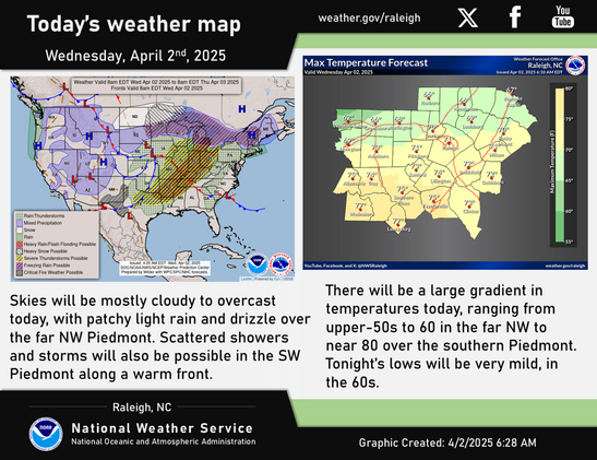
The retreat and presence of the front will contribute to a large temperature gradient over cntl NC today, ranging from upr 50s to around 60 F in the in-situ cold air damming, characterized by widespread low overcast and periods of light rain and drizzle over the far nw Piedmont (nwrn Forsyth Co.), to near 80 F over the srn Piedmont. Large errors/bust potential will also exist in the fronts vicinity. In addition to the stratiform light rain and drizzle in the damming regime, scattered showers and storms will be possible along the front from the Upstate of SC nwd into the srn NC Piedmont late this afternoon through evening, where weak to moderate diurnal destabilization will result from the unseasonably warm temperatures near 80 F and surface dewpoints in the lwr 60s. Despite modest, ~25- 30 kts of mid-level flow, low-level shear will be enhanced by both strong veering in the lowest few kilometers and also backed surface flow along the front, with associated relatively large, clockwise- curved hodographs. As such, some cells may display transient supercell characteristics (ie. rotation and a tendency to move right of the mean wind given the aforementioned character of the shear profiles), from Davidson, Stanly, and Anson Co. and especially points swwd...

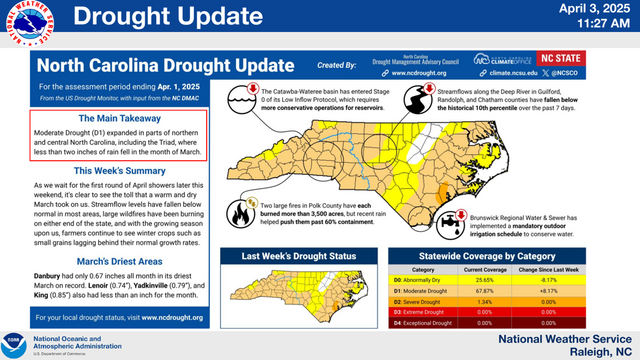
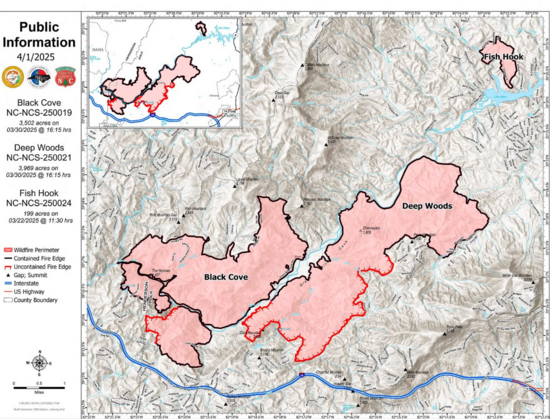
#NCwx #NorthCarolina #BlackCoveComplex

From NC Forest Service on FB: 🔥FIRE INFORMATION UPDATE🔥BLACK COVE COMPLEX🔥APRIL 1, 2025🔥
(Polk and Henderson counties)

For latest information update on the Black Cove Complex as of this morning: ncagr.gov/news/press-releases/

For an updated public information map of the Black Cove Complex: ncagr.gov/divisions/nc-forest-

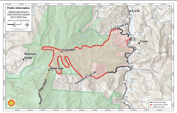
#NCwx #NorthCarolina #RattlesnakeBranchFire

From USFS NC on FB: Good Morning from #RattlesnakeBranchFire in Cruso, NC…We'll go over the list of suggestions you made for further improvements with our local friends with Haywood County Emergency Services and Haywood County Sheriff's Office - North Carolina and we may be able to add more iconic places.

Thanks so much for taking the time to share your ideas with us!

For a printable PDF (you can zoom in...), visit: inciweb-prod-media-bucket.s3.u

#NCwx

Area Forecast Discussion
NWS Raleigh NC
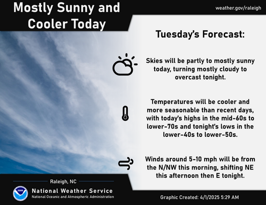
435 AM EDT Tue Apr 1 2025

NEAR TERM

Onshore low-level flow, and veering wind profiles with height/WAA below a prominent, ~850 mb subsidence inversion, will likely result in the development & expansion of an area of stratocumulus ceilings across the Sandhills shortly after midnight, then nwwd across the srn & wrn Piedmont through Wed morning. Low Temps in the 40s, to lwr 50s across the srn Sandhills & srn Piedmont…